


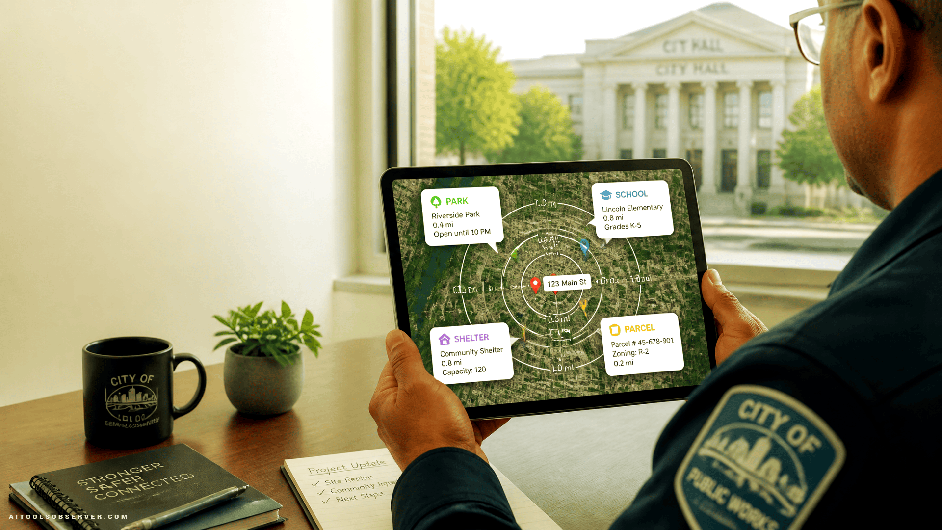
The use case: turning government search into location-aware help
Cities already have websites, service portals, maps, and open data catalogs. The problem is that residents often have to know where to look, what a dataset is called, or which department owns the answer.
AI + GIS changes the interface.
Instead of forcing residents to navigate menus and map layers, the system can take a question like:
- Is my property in a flood zone?
- What construction projects are happening within a mile of my home?
- Where is the nearest park, school, or service center?
- Are there traffic incidents or 311 requests in my neighborhood?
The assistant translates that request into a spatial query, looks at official datasets, and returns something readable.
In plain English: less “please use the parcel viewer,” more “here’s what applies to your address.”
Why GIS makes the chatbot meaningfully better
Without GIS, a chatbot is mostly a text layer over documents and FAQs.
With GIS, it can understand:
- addresses
- parcels
- distances
- boundaries
- nearby assets
- neighborhood-level patterns
That creates a different class of answer.
A resident is no longer just searching for information. They are asking for information in context. GIS provides that context by tying the answer to a location, a radius, a zone, or a map.
This is especially useful for what teams often call “nearest neighbor” searches: find the closest relevant thing to a location. That could be a shelter, a school, a park, an available adoptable pet, or a county office.
It sounds simple. Under the hood, it requires geocoding an address, converting it to a point, comparing it against a dataset, and ranking results by distance. Which is to say: the chatbot gets friendlier, but the plumbing gets more serious.
Maricopa County: a public assistant with spatial search
Maricopa County, Arizona, offers a strong example of this pattern. The county launched a public-facing assistant called Mari and an internal employee-facing counterpart called Marco.
The setup, based on the available context, combines conversational AI with retrieval and GIS tools. The AI handles the dialogue and search orchestration. The GIS layer handles spatial requests.
That architecture matters. It suggests the chatbot is not simply “guessing” from general web text. It is designed to pull from official sources and use mapping tools when the question depends on location.
What residents can ask
Maricopa’s assistant appears positioned to help with a wide range of county questions, including property-related issues, services, jobs, and even pet adoption.
The pet adoption example is a good reminder that “geospatial AI” is not only about zoning maps and flood risk. It can also support everyday service discovery. A resident can ask about available dogs, filter by something specific, and get practical results plus links to continue the task.
That is a nice pattern for civic AI: answer the question, then hand off to the right transactional page.
The spatial part: nearest neighbor and chained context
The more interesting feature is how Mari handles location-aware follow-ups.
If a resident asks for the nearest relevant service to an address, the system can interpret that address geographically, compare it against official point datasets, and return the closest results. That is the classic nearest-neighbor workflow, just wrapped in a chat interface.
It also appears to support contextual chaining. Once the system has a resident’s address during the session, it may be able to use that context for follow-up questions without making the person repeat it.
That is great UX. It is also exactly where privacy and guardrails start doing real work.
Washington, D.C.: AI as the front door to open data
Washington, D.C., is tackling a related problem from a different angle.
Its tool, DC Compass, sits on top of the city’s open data and GIS environment. The goal is not just resident support in the service sense, but easier access to a large pool of public datasets.
That makes the chatbot less like a virtual clerk and more like a conversational search layer for the city’s data portal.
If you have ever opened a public data portal and instantly forgotten why you came, you understand the use case.
What this solves
Open data systems are useful, but they often assume a patient user who understands datasets, categories, and portal logic. Many residents do not want to browse layers or parse schema names. They want an answer.
DC Compass appears designed to bridge that gap by letting residents and employees query datasets in plain language, including spatial ones.
Examples include:
- finding nearby parks or schools
- exploring traffic incidents
- reviewing 311 activity
- creating maps from public data
- asking neighborhood-level questions without manually building a query
This is a subtle but important shift. The city is not replacing open data. It is lowering the skill barrier to using it.
The workflow pattern behind both examples
Maricopa County and Washington, D.C., are solving different public problems, but the workflow pattern is similar:
- A resident asks a natural-language question.
- The system determines whether the answer requires document retrieval, structured data, GIS analysis, or all three.
- Location data is translated into usable spatial inputs.
- Official datasets are queried.
- The answer is returned in plain language, sometimes with maps, links, or next steps.
That orchestration is the real product.
The chatbot is just the visible part. The useful part is the connection between language, trusted data, and geospatial logic.
Why this works better than a search box
Search boxes are fine until the user does not know the right keyword.
Government websites make this worse because the official term often differs from the resident’s term. A resident may ask about “trash day near me” while the webpage says “solid waste collection schedule by service zone.”
AI helps bridge that language mismatch. GIS helps bridge the location mismatch.
Together, they let residents ask the messy version of the question and still get somewhere useful.
That is the practical promise here: fewer dead ends, fewer departmental guessing games, fewer tabs open in quiet frustration.
The catch: the answer is only as good as the map
This is the part public-sector teams seem right to take seriously.
A location-aware assistant can feel authoritative because maps feel factual. But if the underlying data is stale, incomplete, inconsistently maintained, or poorly described, the chatbot can still produce a neat, wrong answer.
So the hard part is not just model quality. It is data quality.
Teams have to think about:
- whether the GIS layers are current
- which datasets are official
- how often data updates
- whether boundaries and addresses resolve cleanly
- how the assistant handles ambiguity
- what happens when data conflicts
A chatbot that says “your parcel is in X zone” needs to be very sure it is pointing to the right parcel. Close enough is not a comforting standard when a resident is making a property, safety, or compliance decision.
Guardrails are not optional
Both examples also point to another reality: location-based AI gets sensitive quickly.
An address can be personal. Parcel information can become personal in context. Internal government questions can touch employee or resident data that should not casually flow through a chat interface.
That is why controls matter:
- warnings before sharing personal information
- restricted access for internal tools
- retention limits
- human review paths
- rules against legal advice or inappropriate disclosure
- grounding responses in official datasets
This is not glamorous product work. It is the work.
If a city wants residents to trust an AI assistant, the assistant needs to know when not to improvise. That is where guardrails start doing real work.
A useful distinction: public assistant vs. data assistant
One helpful way to compare these tools is by job to be done.
Public service assistant
Maricopa’s model leans toward constituent help. The assistant supports service discovery, county questions, and location-aware requests tied to resident needs.
The value is convenience and accessibility.
Open data assistant
D.C.’s model leans toward data access and transparency. The assistant helps residents and staff navigate a broad open data environment through conversation.
The value is discoverability and analytical access.
Different front doors. Similar infrastructure.
What other local governments can learn from this
A city does not need to start with a giant everything-bot.
A more sensible path is narrower:
- pick a high-volume question category
- connect the assistant to trusted GIS layers
- support a small set of spatial query types
- add clear handoff paths to official pages or staff
- test heavily before broad rollout
Good starter use cases might include:
- nearby services and facilities
- property and parcel lookup
- neighborhood projects and closures
- open data exploration
- service requests by area
- eligibility or zoning checks with clear disclaimers
The point is not to sound clever. The point is to reduce friction for residents trying to answer practical, local questions.
Tooling takeaway: what to evaluate if you’re comparing platforms
If you are looking at AI tools for a geospatial public-service workflow, the interesting questions are less about chatbot flair and more about operational fit.
Look for:
- GIS compatibility and spatial query support
- retrieval from official internal or public datasets
- session context handling for follow-up questions
- multilingual support
- privacy controls and retention settings
- human handoff options
- explainability of where answers came from
- deployment options across websites, portals, and hub pages
If the tool cannot reliably connect language to official location data, it is mostly a chatbot costume. That is worth keeping in mind when comparing platforms.
The bigger implication: maps are becoming conversational
This is probably the most important takeaway.
For years, digital government asked residents to adapt to maps, portals, and data catalogs. These new systems flip that around. The resident starts with a question, and the interface handles the translation.
That does not remove the need for maps or portals. It makes them easier to reach and easier to use.
For cities, the smart move is not “add AI” in the abstract. It is to identify where location is the hidden variable in a resident question, then build around that.
Because a lot of civic confusion is really just geography wearing a customer-service disguise.













Comments (0) No comments yet
Want to join this discussion? Login or Register.
No comments yet. Be the first to share your thoughts!