

The Partnership Changing How Responders See Disasters

On June 16, 2026, Carnegie Mellon’s NSF AI Institute for Societal Decision Making (NSF AI-SDM) and Meta’s AI for Good program announced a formal partnership to build AI-powered dynamic situation reports for emergency responders.
The goal is straightforward: turn raw mobility and connectivity data into clear, actionable visualizations that first responders can actually use on the ground during a disaster.
This isn’t a research project that lives in a lab. The tools are being evaluated against real natural disasters happening in 2026 — hurricane season and wildfire season included.
What the AI Tools Actually Do
The core of this system combines two data streams that have rarely been integrated at this scale for emergency response.
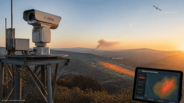
Meta’s aggregated mobility data — already collected through its AI for Good program — shows how populations move before, during, and after a disaster event. Combined with satellite imagery and Meta’s own open-source AI models, including Segment Anything, DINO, and large language models, the system can generate situational awareness that was previously impossible to produce quickly.
Here’s what that looks like in practice:
- Evacuation compliance tracking — Are people actually leaving when ordered to?
- Population density mapping — Where are people still sheltering in place?
- Return monitoring — When do communities start coming back after a disaster passes?
These aren’t abstract metrics. For an emergency manager coordinating search and rescue or resource deployment, knowing where 10,000 people are clustered in real time is the difference between an effective response and a catastrophic one.
Why This Combination of Tools Matters
Most disaster response tools solve one piece of the puzzle. Satellite imagery shows physical damage. Mobility data shows human movement. Language models can synthesize reports. What makes this collaboration notable is the integration — pulling these layers together into a single, interpretable output.
Meta’s Segment Anything model, originally built for image segmentation tasks, becomes a tool for analyzing satellite imagery of affected areas. DINO, Meta’s self-supervised vision model, adds another layer of visual intelligence. Large language models then help translate complex data patterns into plain-language situation reports that responders without data science backgrounds can act on immediately.
The research team at NSF AI-SDM brings the human side of the equation. Their work specifically examines how people perceive risk, how trust shapes decision-making under uncertainty, and how communication design affects behavior during crises. That context matters enormously when you’re trying to build tools that don’t just generate data — but actually change outcomes.
The Academic-Industry Model Working as It Should
Partnerships between universities and tech companies often produce research that never leaves a PDF. This one is structured differently.
NSF AI-SDM already has working relationships with state and local emergency management agencies. The plan is to share these tools directly with those partners during 2026 disaster events, gather real feedback, and iterate. The final tools will be distributed through the Humanitarian Data Exchange and the NSF AI-SDM website — open access, not locked behind a platform.
Laura McGorman, director of Meta AI for Good, framed it clearly: leveraging AI and real-time mobility data has the potential to transform how governments and nonprofits respond to natural disasters. That’s not marketing language when it’s backed by a deployment plan tied to an active disaster season.
Rebecca Nugent, head of CMU’s Department of Statistics and Data Science, described it as a model for how academic-industry collaboration can drive social good. The emphasis on population mobility during disasters, combined with public-facing resources, signals an intent to make this work accessible beyond the research community.
What This Means for the AI Tools Ecosystem
For founders and product teams building in the public sector AI space, this partnership signals a few things worth paying attention to.
Open-source AI models are becoming infrastructure for humanitarian work. Segment Anything and DINO weren’t built for disaster response — but they’re being repurposed for it. That’s a pattern that will accelerate.
Real-time mobility data is becoming a standard input for crisis tools. Any platform serving emergency management, urban planning, or public safety that isn’t thinking about mobility data integration is already behind.
The demand for explainable, actionable AI outputs is real. The emphasis on “clear, simple visualizations” and plain-language situation reports isn’t a design preference — it’s a functional requirement. Tools that produce outputs responders can’t interpret in the field don’t get used.
The Bigger Picture
Natural disasters are becoming more frequent and more severe. The window between a disaster event and an effective response is measured in hours, sometimes minutes. AI tools that compress the time between data and decision aren’t a nice-to-have — they’re becoming critical infrastructure.
What Carnegie Mellon and Meta are building isn’t a finished product. It’s a foundation. The 2026 evaluation phase will reveal what works, what doesn’t, and what needs to be rebuilt. But the architecture — combining mobility data, satellite imagery, open-source vision models, and human decision-making research — is a serious attempt to solve a problem that costs lives when it goes unsolved.
The tools that emerge from this work will be worth watching closely.


Comments (0) No comments yet
Want to join this discussion? Login or Register.
No comments yet. Be the first to share your thoughts!